


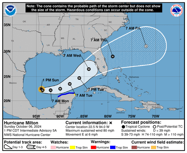
Hurricane Milton rapidly intensified into a Category 1 storm on Sunday, and it has set its path on Florida’s Gulf Coast.
Forecasters predict Milton will make landfall around the Tampa Bay area on Wednesday, bringing with it upwards of 120 mph winds and drenching an area still reeling from Hurricane Helene.
As of 2 p.m. ET on Sunday, Milton was centered about 290 miles west-northwest of Progreso, Mexico, and about 815 miles west-southwest of Tampa. It had maximum sustained winds of nearly 80 mph and was inching north-northeast at 6 mph.
Path of Hurricane Milton
A map from the National Hurricane Center shows Milton continuing to strengthen into a major hurricane as it approaches Florida’s western coast.
“Milton is forecast to rapidly intensify during the next couple of days and become a major hurricane on Monday,” forecasters said.
NOAA/National Hurricane Center
The storm is expected to remain north of Mexico’s Yucatan peninsula, with heavy rainfall expected as Milton makes its way northeast toward Florida. Tropical storm watches are currently in effect from Celestun to Cancún, Mexico.
NOAA/National Hurricane Center
The hurricane center said hurricane and storm surge watches could be issued for parts of Florida later Sunday.
Florida officials prepare for more impact
Florida Gov. Ron DeSantis said Sunday that while it remains to be seen just where Milton will strike, it’s clear that Florida is going to be hit hard. “I don’t think there’s any scenario where we don’t have major impacts at this point,” he said.
“You have time to prepare — all day today, all day Monday, probably all day Tuesday to be sure your hurricane preparedness plan is in place,” the governor said. “If you’re on that west coast of Florida, barrier islands, just assume you’ll be asked to leave.”

NOAA via AP
DeSantis expanded his state of emergency declaration Sunday to 51 counties and said Floridians should prepare for more power outages and disruptions, making sure they have a week’s worth of food and water and are ready to hit the road.
The Federal Emergency Management Agency, meanwhile, coordinated with the governor and briefed President Biden Sunday on how it has staged lifesaving resources.
“I highly encourage you to evacuate” if you’re in an evacuation zone, said Kevin Guthrie, executive director of the Florida Division of Emergency Management. “We are preparing … for the largest evacuation that we have seen, most likely since 2017, Hurricane Irma. “
As many as 4,000 National Guard troops are helping state crews to remove debris, DeSantis said.
“All available state assets … are being marshaled to help remove debris,” DeSantis said. “We’re going 24-7 … it’s all hands on deck.”


 Live Score – ESPN")